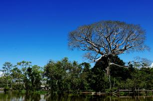
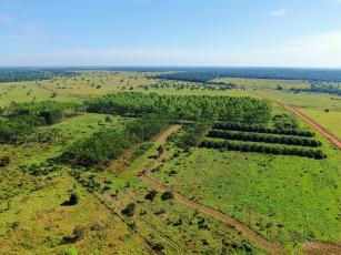
Experts in forest research can now count on an important tool to support studies on biomass and forests. The WebGIS of the Sustainable Landscapes Brazil project presents data obtained through high-precision Light Detection and Ranging (LiDAR) technology and through the remote sensing of three Brazilian biomes: Amazon rainforest, Cerrado and Atlantic rainforest. The free digital geographic information system (GIS) is hosted at Embrapa Agricultural Informatics (Campinas, SP). LiDAR is an airborne laser system that allows one to examine the study area in detail, as it supplies information on terrain surface and vegetation structure. The data are useful for forest inventories and research concerning biomass estimates, carbon stocks and geoglyphs, for instance. The remote sensing analyst Maiza Nara dos Santos, affiliated with the Arthur Bernardes Foundation (Funarbe), explains that it is a display of the results from extensive data collection held in partnership with national and international institutions. With such free, organized data, specialists can dedicate more time and resources to research. Aimed at developing sustainable ecosystem management, the Sustainable Landscapes Project has been coordinated since 2011 by the United States Forest Service (USFS) researcher Michael Keller, a visiting scientist through the Embrapa's cooperation project known as Inverted Labex. The project is supported by the United States Agency for International Development (USAID) and by the US Department of State. The collaboration between USFS and the Brazilian Agricultural Research Corporation (Embrapa) facilitated the generation of high precision LiDAR data with the aim of developing new methods and generating knowledge in the area. Due to the relevance of the partnership, in August 2016 Embrapa renewed the technical cooperation agreement with Funarbe for another five years, according to the general head of Embrapa Agricultural Informatics, Silvia Massruhá. That will allow new data to become available in the WebGIS as they are collected by participating researchers. Border effect studies are another example of work that uses LiDAR data and contributes to forest degradation analyses. The laser scanning technology that is rather disseminated in Europe and the US is still underapplied in Brazil. With the partnerships, it is possible to facilitate access for Brazilian researchers, Maiza emphasizes. The Brazilian Forest Service, one of the partners, published data on logging management and control in the Amazon rainforest, which also favors the elaboration of inventories. A Google Maps-like type of interface, the WebGIS contains information about the Amazon rainforest, the Cerrado and the Atlantic rainforest. Users can choose the Brazilian state and the type of map they prefer from three options of maps available: StreetMap is a traditional map that shows streets and other urban areas; Google Satellite offers satellite-based photographic images; and Google Terrain depicts aspects like spatial topography. Access it here.
Experts in forest research can now count on an important tool to support studies on biomass and forests. The WebGIS of the Sustainable Landscapes Brazil project presents data obtained through high-precision Light Detection and Ranging (LiDAR) technology and through the remote sensing of three Brazilian biomes: Amazon rainforest, Cerrado and Atlantic rainforest.
The free digital geographic information system (GIS) is hosted at Embrapa Agricultural Informatics (Campinas, SP). LiDAR is an airborne laser system that allows one to examine the study area in detail, as it supplies information on terrain surface and vegetation structure. The data are useful for forest inventories and research concerning biomass estimates, carbon stocks and geoglyphs, for instance.
The remote sensing analyst Maiza Nara dos Santos, affiliated with the Arthur Bernardes Foundation (Funarbe), explains that it is a display of the results from extensive data collection held in partnership with national and international institutions. With such free, organized data, specialists can dedicate more time and resources to research.
Aimed at developing sustainable ecosystem management, the Sustainable Landscapes Project has been coordinated since 2011 by the United States Forest Service (USFS) researcher Michael Keller, a visiting scientist through the Embrapa's cooperation project known as Inverted Labex. The project is supported by the United States Agency for International Development (USAID) and by the US Department of State. The collaboration between USFS and the Brazilian Agricultural Research Corporation (Embrapa) facilitated the generation of high precision LiDAR data with the aim of developing new methods and generating knowledge in the area.
Due to the relevance of the partnership, in August 2016 Embrapa renewed the technical cooperation agreement with Funarbe for another five years, according to the general head of Embrapa Agricultural Informatics, Silvia Massruhá. That will allow new data to become available in the WebGIS as they are collected by participating researchers.
Border effect studies are another example of work that uses LiDAR data and contributes to forest degradation analyses. The laser scanning technology that is rather disseminated in Europe and the US is still underapplied in Brazil. With the partnerships, it is possible to facilitate access for Brazilian researchers, Maiza emphasizes. The Brazilian Forest Service, one of the partners, published data on logging management and control in the Amazon rainforest, which also favors the elaboration of inventories.
A Google Maps-like type of interface, the WebGIS contains information about the Amazon rainforest, the Cerrado and the Atlantic rainforest. Users can choose the Brazilian state and the type of map they prefer from three options of maps available: StreetMap is a traditional map that shows streets and other urban areas; Google Satellite offers satellite-based photographic images; and Google Terrain depicts aspects like spatial topography.