GeoMatopiba: Inteligência Territorial Estratégica para o Matopiba
GeoMatopiba: Strategic Territorial Intelligence for Matopiba
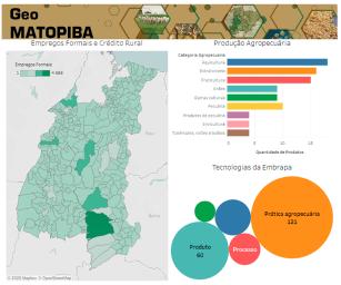
Photo: Territorial, Embrapa
The GeoMatopiba is a free, public-access platform for data management and data analysis operations on the Matopiba region. Its structure includes two environments: Geoweb Matopiba and Interactive Panels. Geoweb Matopiba presents the cartographic database used for the outline and characterization of the region in accordance with the five frames of a Strategic Territorial Intelligence System (SITE): natural, agrarian, agricultural, and socioeconomic, and infrastructure dimensions. The Interactive Panels provide updated data at the municipal level on all agricultural production in the region, agricultural credit, formal jobs in the agricultural sector as well as agricultural technologies, developed by Embrapa and available for adoption in the region. These data are presented in an interactive way, reorganized based on each consultation performed by the user.
Beneficiaries
Public and private managers, extension workers and rural producers
Geographical coverage
All 337 municipalities belonging to the Matopiba agricultural frontier region
Economic and social benefits
The platform can be used to rationally guide the application of other public policies for regional development (rural credit, distribution of seeds, rural extension, promotion of local production arrangements, installation of inspection posts) and crisis management (appearance of new pests, environmental disasters)
Where to find:
http://www.embrapa.br/geomatopiba
Product: Software Launch year: 2020
Country: Brazil Region: Northeast State: Bahia, Maranhão, Piauí, Tocantins Biome: Cerrado
Responsible Unit: Embrapa Territorial