Through satellite images, it will be possible to annually monitor the adoption of Integrated Crop-Livestock (ICL) systems in the country. Artificial intelligence recognizes patterns and automatically detects agricultural areas with sustainable production systems. The methodology distinguishes single soybeans crop from double cropping with cereals or cotton following a summer soybeans crop, for example. The algorithm developed is being adapted to also detect no-till farming systems and all variations of integrated production systems. The monitoring system will generate spatialized data that can be made available by regions, states, micro-regions, municipalities, biomes, or hydrographic basins. The indicators and data generated will contribute to the governance of the low carbon agriculture plan Plano ABC+ and the inventory of greenhouse gas emissions from Brazilian agriculture. Embrapa researchers and partners have developed a methodology for the remote and automated satellite monitoring of the expansion of areas with integrated agricultural production systems in Brazil. The mapping and the data generated make it possible to annually obtain quantitative indicators about the adoption of those systems and consequently monitor the expansion of sustainable intensification in the country. The technical-scientific methodology already makes it possible to detect areas with double cropping (soybean and corn or cotton in succession, for example) and with Integrated Crop-Livestock systems (ICLS). Scientists have been working to adjust the remote sensing methodology to other modalities: Integrated Livestock-Forestry (ILF); Integrated Crop-Forestry (ICF) and Integrated Crop-Livestock-Forestry (ICLF) systems. The objective is to develop methodological protocols, based on artificial intelligence, which will integrate a system that can automatically analyze satellite images, providing updated indicators on the areas that adopt such sustainable production systems. The information generated will be useful, for example, to manage sectoral public policies and to estimate the mitigation of greenhouse gases (GHGs) in agriculture. The methodology was developed within the scope of the GeoABC project, which aimed to develop methodologies and technological innovations for the satellite monitoring of low-carbon agriculture, in support of the governance of the Low Carbon Agriculture Plan, Plano ABC (see box below). Margareth Simões, a researcher at Embrapa Soils (Rio de Janeiro, RJ) who led the study, says that national agriculture is going through an important process of sustainable intensification that has led to the consolidation of production centers and the growing adoption of high-yield sustainable production systems. She points out as examples the expansion of areas with double cropping (either annual crop + summer second crop or summer crop + winter crop), the adoption of the no-till farming system (NTFS), the recovery of pastures in support of high-performance livestock farming, and, especially, a huge adherence to Integrated Agricultural Production Systems in all their variations. However, the scientist explains that due to the lack of methodologies that could remotely detect the expansion of these production systems so far, the public and private bodies in the sector have not had adequate information to estimate the level of adoption and expansion in these technologies. Such data are essential to support public policies for the sector, according to her. “The country urgently needs indicators and metrics to quantify and demonstrate how much its agriculture and livestock has been evolving towards the desired sustainable intensification”, Simões ponders. The technological solutions used The researchers explain that the methodology developed within the scope of the GeoABC project is based on the convergence of several technical-scientific developments based on the use of free, open-source solutions. One of them is the methodology of digital classification of time series of satellite images using artificial intelligence algorithms (machine learning). Another is the use of cloud computing platforms and high-performance parallel computing. Margareth Simões clarifies that, at the beginning of the work, many technical challenges had to be overcome. Starting with the difficulty in detecting terrestrial targets as complex and dynamic as the ICLF systems by remote sensing, due to the different strategies adopted by farmers and the inherent integration of different crop, livestock, and forest elements within intercropping, succession, and rotation practices. “This challenge required working with time series of satellite images based on the concept of multidimensional data cubes,” she explains. The researcher also highlights that there was a need to have an effective methodology to extract information and a robust structure to process a massive amount of data. “The integration of data cubes, machine learning, and high performance parallel computing solutions solved our problem,” she recalls. Patrick Kuchler, a researcher linked to the GeoABC research group at the State University of Rio de Janeiro (UERJ/PPG-MA), recalls that another major difficulty faced by the team was the acquisition of field data since the classification and validation algorithms need a large amount of qualified, georeferenced data with a detailed history of each sampled plot. “It was a great effort to carry out the field campaigns and, luckily, we were able to count on the invaluable partnership of technicians and farmers who helped us a lot”, says Kuchler. Embrapa Soils researcher Rodrigo Ferraz highlights the hierarchical classification structure, capable of distinguishing single soybean from soybeans in double cropping (soybeans+cereals or soybeans+cotton) and Integrated Crop-Livestock (ICL) systems in direct (soybean+pasture) or indirect (soybean+cereal+pasture) crop succession. “The algorithm to detect such categories is fully developed and can already compose a protocol for systematic monitoring. For the other variations of the integrated systems (ICFS, ILFS, and ICLFS), as well as for the no-till farming system, it will be necessary to continue the research work”, he reveals. Ferraz adds that by using the same method applied to a broader learning base, with the machine learning algorithms they already developed, the team will be able to consolidate the other protocols to provide Brazil with a complete monitoring system. "It is worth noting that the monitoring system generates spatialized data, making it possible to compute statistics in different spatial units of analysis, which can be either political and administrative dimensions such as country, states, micro-regions, municipalities and agricultural development centers, or physiographic units, such as biomes and watersheds.” The methodology has been tested in Mato Grosso The computational algorithms for the detection and monitoring of the different production systems (ICL and double-cropping system) were tested in the state of Mato Grosso, in the period from 2012 to 2019. The results show the potential that the classification methodology has for the annual mapping or monitoring on a national scale (see figures 1 to 4). Kuchler explains that Figure 1 shows the clear intensification of agriculture that took place in Mato Grosso between the 2012/2013 and 2018/2019 crop years based on the Kernel density method. Figure 1: Kernel density maps showing the intensification of production systems in the soybean chain in Mato Grosso between the 2012/2013 and 2018/2019 crop years. Figure 2 shows a cartogram that represents the growth of ICL areas by municipalities in Mato Grosso between the 2012/2013 and 2018/2019 crop years. In figures 3 and 4, the evolution of the areas of soybean+cereal, soybean+cotton, and ICL systems for the harvest years from 2012/2013 to 2018/2019 can be seen. Figure 2: Cartogram of municipalities in the state of Mato Grosso, ranked according to areas of Integrated Crop-Livestock (ICL) systems in the 2018/2019 crop year. Figure 3: Map of Integrated Crop-Livestock (ICL) and double-cropping systems in Mato Grosso, in the 2018/2019 crop year. Figure 4: Graph showing the evolution of areas with Integrated Crop-Livestock (ICL) and double-cropping systems in Mato Grosso, between the 2012/2013 and 2018/2019 harvest years. “In the case of Mato Grosso, we can highlight that the ICL area jumped from approximately 1.1 million to 2.6 million hectares between 2013 and 2019, that is, it more than doubled in the period of seven harvests”, Kuchler highlights. The results of the study to identify ICL areas in Mato Grosso are in a scientific article – download it here. Next steps "Once we have all the methodological protocols developed, the objective is to integrate them into a platform that can carry out the annual monitoring of all production systems recommended by the Plan for Adaptation to Climate Change and Low Carbon Emission in Agriculture (Plan ABC+)”, explains Margareth Simões. Embrapa Soils researcher Pedro Freitas adds that the developed methodology applies to various production systems involving annual crops such as soybeans, corn, and cotton, in several regions of the country. Ferraz points out that, in support of sectoral policies and management, the team is also formulating and proposing several spatial indices that present, for example, the rates of expansion and adoption of integrated production systems or the process of sustainable intensification, such as an Index of Absolute Expansion, Relative Expansion Index, Adoption Index, and Sustainable Intensification Index. “We are already working on making the results available on an interactive platform, with the presentation of maps, data, statistics, and indicators within dashboards. We understand that we must widely publicize the data produced, and the best way to do this will be through a digital platform, such as the platform of the National Soil Survey and Interpretation Program in Brazil (PronaSolos). It will be a technological asset, which we are calling the GeoABC Platform, and which will be very useful to the Ministry of Agriculture (MAPA) in carrying out the ABC+ Plan”, he projects. Award-winning methodology The methodology to map integrated Crop-Livestock systems developed within the GeoABC project won two scientific awards in 2021. In July, it won first place in the overall category at the 3rd edition of the MapBiomas Award, promoted by the Annual Land Use and Cover Mapping Project in Brazil, an initiative that involves a collaborative network with experts in biomes, land uses, remote sensing, GIS, and computer science. The awarded work showed the development of the methodology and the results of the classification of the ICL and double cropping systems for the state of Mato Grosso, based on the soybean mapping provided by MapBiomas. In June, the methodology had already been awarded 3rd place overall at the II World Congress on Integrated Crop-Livestock-Forestry Systems, promoted by the Ministry of Agriculture, Embrapa, ICLF Network Association, Famasul System, and and the Mato Grosso do Sul State Secretariat of Environment, Economic Development, Production and Family Farming (Semagro). Who can benefit from the methodology According to the researchers, the methodology will be able to meet the demands from not only the Brazilian Ministry of Agriculture but also from different actors in the production sector, research institutions, universities, and government or private sector bodies. For the Ministry of Agriculture, the state secretariats of agriculture, and other sectoral bodies of the federal and state government, monitoring will allow the generation of data, information, statistics, and spatial indicators that will be able to support not only the planning and management of public policies directly related to the theme, such as the aforementioned ABC+ Plan, as well as sectoral policies related to technology transfer and to logistics and infrastructure in support of the production sector. “The data generated will also contribute to the inventory and monitoring of greenhouse gas (GHG) emissions in national agriculture. They will also make it possible to assess the potential to mitigate GHG emissions, increase efficiency in the use of inputs and effectively reduce soil loss due to water erosion. And they will meet the estimate and availability of agro-environmental data on platforms such as MAPA's Observatory of Brazilian Agriculture and PronaSolos”, adds Pedro Freitas. Simões also points out gains for Brazil's performance in International Forums, as monitoring contributes to the establishment of agri-environmental indicators recommended by the Organization for Economic Cooperation and Development (OECD) and by the United Nations (UN), within the scope of the Sustainable Development Goals (SDGs). "Brazil will have statistical data and agro-environmental indicators that, in addition to subsidizing the decision-making, planning and management processes of the agricultural sector, will make it possible to demonstrate how national agriculture is moving towards sustainability, empowering the country in international trade negotiation forums and environmental”, she predicts. For the production sector, the statistical data generated may guide private investments in either production or infrastructure and commercial logistics of the input chain. The information can also guide financial sector agents in granting insurance or agricultural credit. The development networks and observatories will also be able to use the GeoABC methodology to monitor the integrated systems. Embrapa Soils researcher Renato Rodrigues, president of the Management Council of the ICLF Network, highlights the importance of the methodology developed by Embrapa and partners. “Today, it is not known precisely where integrated systems occur or what their adoption rates are. Therefore, data on the expansion of the Integrated Crop-Livestock systems will be very welcome for the planning of work, not only for the iCLF Network, but I'm sure, for the entire agribusiness sector that is interested in sustainable intensification", he comments. Ferraz adds the example of the Multi-institutional Platform to Monitor Reductions of Greenhouse Gas Emissions in Agriculture (ABC Platform), managed by the Ministry of Environment, and the ABC Observatory, maintained by the Getúlio Vargas Foundation (FGV) , as initiatives that could also directly benefit from the data generated by the ICLFS monitoring system. Finally, for research institutions and universities, these data will be able to facilitate technical-scientific studies on agronomic, geographic, logistical, environmental themes and other topics, the researchers enumerate. GeoABC project The GeoABC project started in 2015 with the aim of evaluating and developing innovative methods and techniques in remote sensing and spatial data integration for the detection of cultivation practices and production systems. The focus was on Integrated Crop-Livestock-Forestry systems (ICLFS) and variations, which constitute one of the axes of the low carbon emission policy in agriculture. With the financial support of the program of the Coordination for the Improvement of Higher Education Personnel and the French Committee for the Evaluation of University Cooperation with Brazil (Capes/Cofecub), the GeoABC project delivered several results, including the methodology to monitor ICL systems. Such deliverables resulted from the joint work of Embrapa Soils with the State University of Rio de Janeiro (UERJ/PPG-MA), which also counted on a partnership with the French institutions Center for International Cooperation in Agricultural Research for Development (Cirad/UMR TETIS) and the University Rennes 2 (LETG-Rennes-Costel). Regarding Brazil-France cooperation, Agnès Bégué, a researcher from Cirad, highlights the importance of bilateral cooperation projects like the GeoABC project in the development of methodologies applied to the agricultural reality of the countries involved. "I consider that the GeoABC project was a successful example of a cooperation project, not only due to the exchange and training of doctoral students and academic-scientific production, but also due to the delivery of applicable methodologies, in support of sustainable development policies, especially those related to the decarbonization of the economy, which, today, after COP 26, is in order in all world agendas, following the example of the Low-Carbon Agriculture Policy in Brazil”. The studies made it possible to assess the potential use of these technologies and the consequent development of a methodology to provide spatial indicators, especially regarding ICLS, in support of the monitoring and governance of the ABC Plan, led by the Ministry of Agriculture. “Soon, we will have a complete system to monitor low carbon agriculture,” Simões reinforces. Image: Gabriel Faria
Photo: Gabriel Faria

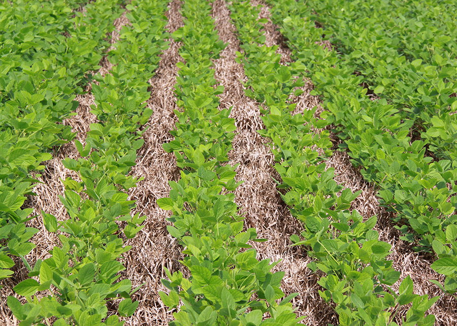
The mapping and the data it generates allow obtaining quantitative indicators on the adoption of integrated systems. In the photo, cattle in ICL system
-
Through satellite images, it will be possible to annually monitor the adoption of Integrated Crop-Livestock (ICL) systems in the country. -
Artificial intelligence recognizes patterns and automatically detects agricultural areas with sustainable production systems. -
The methodology distinguishes single soybeans crop from double cropping with cereals or cotton following a summer soybeans crop, for example. -
The algorithm developed is being adapted to also detect no-till farming systems and all variations of integrated production systems. -
The monitoring system will generate spatialized data that can be made available by regions, states, micro-regions, municipalities, biomes, or hydrographic basins. -
The indicators and data generated will contribute to the governance of the low carbon agriculture plan Plano ABC+ and the inventory of greenhouse gas emissions from Brazilian agriculture. |
Embrapa researchers and partners have developed a methodology for the remote and automated satellite monitoring of the expansion of areas with integrated agricultural production systems in Brazil. The mapping and the data generated make it possible to annually obtain quantitative indicators about the adoption of those systems and consequently monitor the expansion of sustainable intensification in the country.
The technical-scientific methodology already makes it possible to detect areas with double cropping (soybean and corn or cotton in succession, for example) and with Integrated Crop-Livestock systems (ICLS). Scientists have been working to adjust the remote sensing methodology to other modalities: Integrated Livestock-Forestry (ILF); Integrated Crop-Forestry (ICF) and Integrated Crop-Livestock-Forestry (ICLF) systems. The objective is to develop methodological protocols, based on artificial intelligence, which will integrate a system that can automatically analyze satellite images, providing updated indicators on the areas that adopt such sustainable production systems. The information generated will be useful, for example, to manage sectoral public policies and to estimate the mitigation of greenhouse gases (GHGs) in agriculture.
The methodology was developed within the scope of the GeoABC project, which aimed to develop methodologies and technological innovations for the satellite monitoring of low-carbon agriculture, in support of the governance of the Low Carbon Agriculture Plan, Plano ABC (see box below).
Margareth Simões, a researcher at Embrapa Soils (Rio de Janeiro, RJ) who led the study, says that national agriculture is going through an important process of sustainable intensification that has led to the consolidation of production centers and the growing adoption of high-yield sustainable production systems. She points out as examples the expansion of areas with double cropping (either annual crop + summer second crop or summer crop + winter crop), the adoption of the no-till farming system (NTFS), the recovery of pastures in support of high-performance livestock farming, and, especially, a huge adherence to Integrated Agricultural Production Systems in all their variations.
However, the scientist explains that due to the lack of methodologies that could remotely detect the expansion of these production systems so far, the public and private bodies in the sector have not had adequate information to estimate the level of adoption and expansion in these technologies. Such data are essential to support public policies for the sector, according to her. “The country urgently needs indicators and metrics to quantify and demonstrate how much its agriculture and livestock has been evolving towards the desired sustainable intensification”, Simões ponders.
 The technological solutions used
The researchers explain that the methodology developed within the scope of the GeoABC project is based on the convergence of several technical-scientific developments based on the use of free, open-source solutions. One of them is the methodology of digital classification of time series of satellite images using artificial intelligence algorithms (machine learning). Another is the use of cloud computing platforms and high-performance parallel computing. Margareth Simões clarifies that, at the beginning of the work, many technical challenges had to be overcome. Starting with the difficulty in detecting terrestrial targets as complex and dynamic as the ICLF systems by remote sensing, due to the different strategies adopted by farmers and the inherent integration of different crop, livestock, and forest elements within intercropping, succession, and rotation practices. “This challenge required working with time series of satellite images based on the concept of multidimensional data cubes,” she explains.
The researcher also highlights that there was a need to have an effective methodology to extract information and a robust structure to process a massive amount of data. “The integration of data cubes, machine learning, and high performance parallel computing solutions solved our problem,” she recalls.
Patrick Kuchler, a researcher linked to the GeoABC research group at the State University of Rio de Janeiro (UERJ/PPG-MA), recalls that another major difficulty faced by the team was the acquisition of field data since the classification and validation algorithms need a large amount of qualified, georeferenced data with a detailed history of each sampled plot. “It was a great effort to carry out the field campaigns and, luckily, we were able to count on the invaluable partnership of technicians and farmers who helped us a lot”, says Kuchler.
Embrapa Soils researcher Rodrigo Ferraz highlights the hierarchical classification structure, capable of distinguishing single soybean from soybeans in double cropping (soybeans+cereals or soybeans+cotton) and Integrated Crop-Livestock (ICL) systems in direct (soybean+pasture) or indirect (soybean+cereal+pasture) crop succession. “The algorithm to detect such categories is fully developed and can already compose a protocol for systematic monitoring. For the other variations of the integrated systems (ICFS, ILFS, and ICLFS), as well as for the no-till farming system, it will be necessary to continue the research work”, he reveals.
Ferraz adds that by using the same method applied to a broader learning base, with the machine learning algorithms they already developed, the team will be able to consolidate the other protocols to provide Brazil with a complete monitoring system. "It is worth noting that the monitoring system generates spatialized data, making it possible to compute statistics in different spatial units of analysis, which can be either political and administrative dimensions such as country, states, micro-regions, municipalities and agricultural development centers, or physiographic units, such as biomes and watersheds.”
The methodology has been tested in Mato Grosso
The computational algorithms for the detection and monitoring of the different production systems (ICL and double-cropping system) were tested in the state of Mato Grosso, in the period from 2012 to 2019. The results show the potential that the classification methodology has for the annual mapping or monitoring on a national scale (see figures 1 to 4).
Kuchler explains that Figure 1 shows the clear intensification of agriculture that took place in Mato Grosso between the 2012/2013 and 2018/2019 crop years based on the Kernel density method.
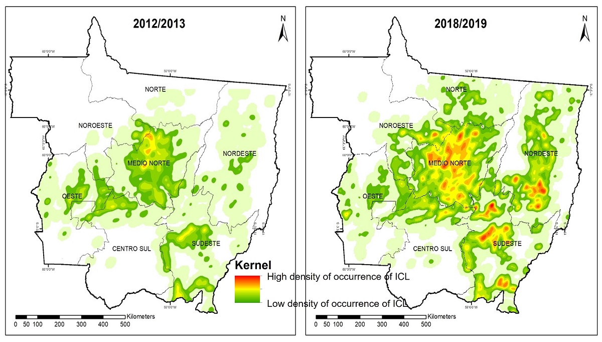
Figure 1: Kernel density maps showing the intensification of production systems in the soybean chain in Mato Grosso between the 2012/2013 and 2018/2019 crop years.
Figure 2 shows a cartogram that represents the growth of ICL areas by municipalities in Mato Grosso between the 2012/2013 and 2018/2019 crop years. In figures 3 and 4, the evolution of the areas of soybean+cereal, soybean+cotton, and ICL systems for the harvest years from 2012/2013 to 2018/2019 can be seen.
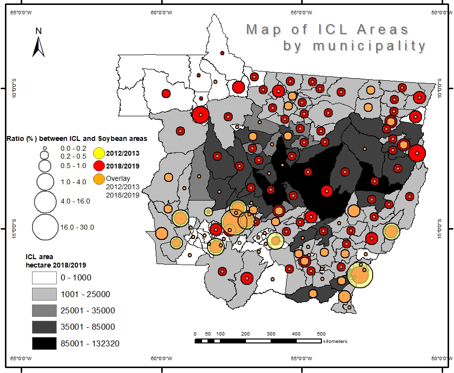
Figure 2: Cartogram of municipalities in the state of Mato Grosso, ranked according to areas of Integrated Crop-Livestock (ICL) systems in the 2018/2019 crop year.
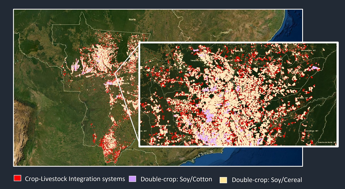
Figure 3: Map of Integrated Crop-Livestock (ICL) and double-cropping systems in Mato Grosso, in the 2018/2019 crop year.
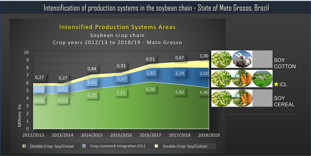
Figure 4: Graph showing the evolution of areas with Integrated Crop-Livestock (ICL) and double-cropping systems in Mato Grosso, between the 2012/2013 and 2018/2019 harvest years.
“In the case of Mato Grosso, we can highlight that the ICL area jumped from approximately 1.1 million to 2.6 million hectares between 2013 and 2019, that is, it more than doubled in the period of seven harvests”, Kuchler highlights.
The results of the study to identify ICL areas in Mato Grosso are in a scientific article – download it here.
Next steps
"Once we have all the methodological protocols developed, the objective is to integrate them into a platform that can carry out the annual monitoring of all production systems recommended by the Plan for Adaptation to Climate Change and Low Carbon Emission in Agriculture (Plan ABC+)”, explains Margareth Simões.
Embrapa Soils researcher Pedro Freitas adds that the developed methodology applies to various production systems involving annual crops such as soybeans, corn, and cotton, in several regions of the country.
Ferraz points out that, in support of sectoral policies and management, the team is also formulating and proposing several spatial indices that present, for example, the rates of expansion and adoption of integrated production systems or the process of sustainable intensification, such as an Index of Absolute Expansion, Relative Expansion Index, Adoption Index, and Sustainable Intensification Index.
“We are already working on making the results available on an interactive platform, with the presentation of maps, data, statistics, and indicators within dashboards. We understand that we must widely publicize the data produced, and the best way to do this will be through a digital platform, such as the platform of the National Soil Survey and Interpretation Program in Brazil (PronaSolos). It will be a technological asset, which we are calling the GeoABC Platform, and which will be very useful to the Ministry of Agriculture (MAPA) in carrying out the ABC+ Plan”, he projects.
Award-winning methodology The methodology to map integrated Crop-Livestock systems developed within the GeoABC project won two scientific awards in 2021. In July, it won first place in the overall category at the 3rd edition of the MapBiomas Award, promoted by the Annual Land Use and Cover Mapping Project in Brazil, an initiative that involves a collaborative network with experts in biomes, land uses, remote sensing, GIS, and computer science. The awarded work showed the development of the methodology and the results of the classification of the ICL and double cropping systems for the state of Mato Grosso, based on the soybean mapping provided by MapBiomas.
In June, the methodology had already been awarded 3rd place overall at the II World Congress on Integrated Crop-Livestock-Forestry Systems, promoted by the Ministry of Agriculture, Embrapa, ICLF Network Association, Famasul System, and and the Mato Grosso do Sul State Secretariat of Environment, Economic Development, Production and Family Farming (Semagro). |
Who can benefit from the methodology
According to the researchers, the methodology will be able to meet the demands from not only the Brazilian Ministry of Agriculture but also from different actors in the production sector, research institutions, universities, and government or private sector bodies.
For the Ministry of Agriculture, the state secretariats of agriculture, and other sectoral bodies of the federal and state government, monitoring will allow the generation of data, information, statistics, and spatial indicators that will be able to support not only the planning and management of public policies directly related to the theme, such as the aforementioned ABC+ Plan, as well as sectoral policies related to technology transfer and to logistics and infrastructure in support of the production sector.
“The data generated will also contribute to the inventory and monitoring of greenhouse gas (GHG) emissions in national agriculture. They will also make it possible to assess the potential to mitigate GHG emissions, increase efficiency in the use of inputs and effectively reduce soil loss due to water erosion. And they will meet the estimate and availability of agro-environmental data on platforms such as MAPA's Observatory of Brazilian Agriculture and PronaSolos”, adds Pedro Freitas.
Simões also points out gains for Brazil's performance in International Forums, as monitoring contributes to the establishment of agri-environmental indicators recommended by the Organization for Economic Cooperation and Development (OECD) and by the United Nations (UN), within the scope of the Sustainable Development Goals (SDGs). "Brazil will have statistical data and agro-environmental indicators that, in addition to subsidizing the decision-making, planning and management processes of the agricultural sector, will make it possible to demonstrate how national agriculture is moving towards sustainability, empowering the country in international trade negotiation forums and environmental”, she predicts.
For the production sector, the statistical data generated may guide private investments in either production or infrastructure and commercial logistics of the input chain. The information can also guide financial sector agents in granting insurance or agricultural credit.
The development networks and observatories will also be able to use the GeoABC methodology to monitor the integrated systems. Embrapa Soils researcher Renato Rodrigues, president of the Management Council of the ICLF Network, highlights the importance of the methodology developed by Embrapa and partners. “Today, it is not known precisely where integrated systems occur or what their adoption rates are. Therefore, data on the expansion of the Integrated Crop-Livestock systems will be very welcome for the planning of work, not only for the iCLF Network, but I'm sure, for the entire agribusiness sector that is interested in sustainable intensification", he comments.
Ferraz adds the example of the Multi-institutional Platform to Monitor Reductions of Greenhouse Gas Emissions in Agriculture (ABC Platform), managed by the Ministry of Environment, and the ABC Observatory, maintained by the Getúlio Vargas Foundation (FGV) , as initiatives that could also directly benefit from the data generated by the ICLFS monitoring system.
Finally, for research institutions and universities, these data will be able to facilitate technical-scientific studies on agronomic, geographic, logistical, environmental themes and other topics, the researchers enumerate.
 GeoABC project GeoABC project
The GeoABC project started in 2015 with the aim of evaluating and developing innovative methods and techniques in remote sensing and spatial data integration for the detection of cultivation practices and production systems. The focus was on Integrated Crop-Livestock-Forestry systems (ICLFS) and variations, which constitute one of the axes of the low carbon emission policy in agriculture. With the financial support of the program of the Coordination for the Improvement of Higher Education Personnel and the French Committee for the Evaluation of University Cooperation with Brazil (Capes/Cofecub), the GeoABC project delivered several results, including the methodology to monitor ICL systems. Such deliverables resulted from the joint work of Embrapa Soils with the State University of Rio de Janeiro (UERJ/PPG-MA), which also counted on a partnership with the French institutions Center for International Cooperation in Agricultural Research for Development (Cirad/UMR TETIS) and the University Rennes 2 (LETG-Rennes-Costel). Regarding Brazil-France cooperation, Agnès Bégué, a researcher from Cirad, highlights the importance of bilateral cooperation projects like the GeoABC project in the development of methodologies applied to the agricultural reality of the countries involved. "I consider that the GeoABC project was a successful example of a cooperation project, not only due to the exchange and training of doctoral students and academic-scientific production, but also due to the delivery of applicable methodologies, in support of sustainable development policies, especially those related to the decarbonization of the economy, which, today, after COP 26, is in order in all world agendas, following the example of the Low-Carbon Agriculture Policy in Brazil”. The studies made it possible to assess the potential use of these technologies and the consequent development of a methodology to provide spatial indicators, especially regarding ICLS, in support of the monitoring and governance of the ABC Plan, led by the Ministry of Agriculture.
“Soon, we will have a complete system to monitor low carbon agriculture,” Simões reinforces. Image: Gabriel Faria |
Fernando Gregio (MTb 42.280/SP)
Embrapa Soils
Press inquiries
solos.imprensa@embrapa.br
Proofreading of translation into English: Mariana Medeiros (13044/DF)
General Secretariat
Further information on the topic
Citizen Attention Service (SAC)
www.embrapa.br/contact-us/sac/