GeoSaltus - Classification and Spatialization of Carbon Stock in Natural and Planted Forests Using Remote Sensing
GeoSaltus - Classification and Spatialization of Carbon Stock in Natural and Planted Forests Using Remote Sensing
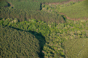
Photo: KOCH, Zig
Forest systems are part of an important land-use strategy aimed at the maintenance of biodiversity, at the commercialization of wood products and other products, at quality of life and at environmental services such as carbon fixation. The greenhouse gas emission flows and the carbon stocked in the forests are indispensable information, and their estimation may support public policies on development and sustainability. Project GeoSaltus focuses on the use of geotechnologies for the development of methods for the assessment of greenhouse gases and forest carbon stock. Its objective is to digitally classify and estimate the carbon stock of reference natural and planted forest areas in the Cerrado, Amazônia, Cerrado/Amazônia transition, Pantanal, Mata Atlântica and Pampa biomes using remote sensing. The use of satellite images and geographic information systems is an adequate strategy because of the significantly lower time necessary to perform a forest classification and of the possibility of extrapolating characteristics obtained in local inventories to wide areas. Other objectives of the project are: to systematize a geographic database of information on greenhouse gas emissions and carbon stock in natural and planted forests at the reference areas studied; to obtain a set of spectral variables for natural forests from orbital remote sensors; to apply different digital classification models to native and planted forests by means of correlating spectral variables and biophysical parameters; and to spatialize the biophysical parameters of native and planted forests using carbon maps of the studied areas. We expect to produce results: with technical and scientific impacts, by generating processes and methods of forest carbon stock estimation by means of remote sensing; with economical and environmental impacts, by generating carbon mapping protocols which are less costly than the traditional protocols and which offer possibilities of extrapolating local environmental characteristics to wider geographic regions; and with governance impacts, by producing a spatially explicit database on greenhouse gas and carbon stock which will support governmental decision-making and public policies for sustainable development. For more information and to access the project’s webgis, please access: http://www.cnpm.embrapa.br/projetos/geosaltus/
Status: Completed Start date: Fri Jun 01 00:00:00 GMT-03:00 2012 Conclusion date: Wed May 31 00:00:00 GMT-03:00 2017