SOMABRASIL - System for the Observation and Monitoring of Agriculture in Brazil
SOMABRASIL - System for the Observation and Monitoring of Agriculture in Brazil

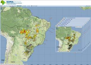
Photo: SOMABrasil, Embrapa Monitoramento por Satélite
The agribusiness production chains represent 26.4% of Brazil’s GDP, 36% of exports and 39% of the jobs generated in the internal market. The generation of geospatial information about the Brazilian agriculture supports decisions and public policies at different levels and scales. The System for Observation and Monitoring of Agriculture in Brazil (SOMABRASIL) aims to organize and integrate census data and information generated from satellite images into a single database for the whole country, favoring the characterization and analysis of agricultural data and the conservation of natural resources. Available on the Internet, the system gathers in WebGIS databases of natural resources and agriculture, including information about production and the IBGE Agricultural Census, data generated by IBAMA and Inpe programs, mappings performed by Embrapa and other institutions, in addition to information about relief, hydrography, logistics, protected areas and agricultural potential. The interface proposed by Embrapa Satellite Monitoring aims at enabling the user’s interaction with databases through basic and advanced queries to generate information that is useful for zonings, monitoring of the spatial dynamics of agriculture, research priorities, and public policy. The adoption of international regulations and standards favors the interoperability of content and services and offers a general and integrated view of the agricultural and livestock potential from a municipal to a national scale. This project aims to develop and implement new query methods, models and simulations of geospatial data within this system, and to incorporate technology transfer actions through data interoperability and meeting specific demands from users or group of users. For more information, please visit: http://mapas.cnpm.embrapa.br/somabrasil/webgis.html
Status: Completed Start date: Tue Oct 01 00:00:00 GMT-03:00 2013 Conclusion date: Fri Sep 30 00:00:00 GMT-03:00 2016
Head Unit: Embrapa Territorial
Project leader: Carlos Alberto de Carvalho
Contact: carlos-alberto.carvalho@embrapa.br


