Unit
Embrapa Soils
 Busca de Projetos
GEOABC: METHODOLOGIES AND TECHNOLOGICAL INNOVATIONS FOR THE MONITORING AND PLANNING OF LOW CARBON AGRICULTURE IN SUPPORT OF THE LOW CARBON AGRICULTURE PLAN GOVERNANCE

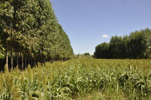
Photo: LOBATO, Breno
The project aims at assessing methods and innovative techniques in the area of Remote Sensing and spatial data integration for detection in cultivation practices and production systems, especially integrated crop-livestock-forestry systems (ICLFs) and variations, which constitute one of the key points of the low carbon agriculture policy.
On a local scale, the goal is to evaluate the potential of new techniques and methodologies that apply to the new Sentinel 2 sensor with regard to the detection and identification of integrated production systems. On a sub-regional scale, the project is going to evaluate methods to monitor the evolution of agricultural landscapes considering the transition from conventional systems to integrated low carbon systems.
Therefore, the main purpose of the project is strictly the evaluation of new techniques and remote sensors with regard to their potential use for the development of a methodology that could supply spatial indicators to support the monitoring and governance efforts of the Low Carbon Agriculture Plan - Sectoral Plan of Mitigation and Adaptation to Climate Change that aims at the consolidation of a Low Carbon Agriculture Economy (http://www.agricultura.gov.br). On the other hand, in the scientific arena, the methods will inform studies on land use dynamics related to the adoption of low carbon production systems and the effective mitigation of GHG emissions, in the context of ongoing climate change. The project also contributes to the consolidation of cooperation between UMR TETIS/CiradIRSTEAUniv. AGroParisTech, IRD/UMR EspaceDev, UERJ/PPGMA, Embrapa
Ecosystem: Amazonic, Cerrados Region, Ecological Transition
Status: Completed Start date: 01/2015 Conclusion date: 12/2018
Head Unit: Embrapa Soils
Project leader: Margareth Goncalves Simoes
Contact: margareth.simoes@embrapa.br


