Unidade
Embrapa Territorial
 Busca de Projetos
Geotecnologias para incrementar a competitividade e sustentabilidade da Agricultura Familiar no Circuito das Frutas do Estado de São Paulo - GPAF

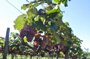
Foto: MINITTI, André Fachini
A agricultura familiar é responsável por 70% da produção de alimentos consumidos no Brasil, segundo dados do IBGE. Seu formato de produção propicia a interação entre gestão e trabalho; gera grande número de postos de trabalho, além de apresentar um viés para a sustentabilidade socioeconômica e ambiental, preservando as tradições e os costumes locais. Formado pelos municípios de Atibaia, Indaiatuba, Itupeva, Itatiba, Jundiaí, Jarinu, Louveira, Morungaba, Valinhos e Vinhedo, o Circuito das Frutas do Estado de São Paulo é um polo de produção agrícola familiar que surgiu em 2000 com a criação de uma associação de pequenos produtores rurais que buscavam o desenvolvimento da região e tendo como foco a permanência do homem no campo por meio da fruticultura, assim como uma alternativa para a geração de renda por meio de um polo turístico rural. Importante região de agricultura familiar, o Circuito das Frutas tem sua produção destinada tanto ao comércio estadual quanto à exportação, com destaque para as culturas da uva, morango, pêssego, goiaba, ameixa, caqui, acerola e figo. Nesse contexto, o projeto “Geotecnologias e pesquisa participativa para a agricultura familiar no Circuito das Frutas - GPAF” busca, por meio da pesquisa participativa e das geotecnologias, promover a sustentabilidade da propriedade rural, fortalecendo a competividade e o sentimento de pertencimento à terra dos agricultores familiares dos municípios integrantes do Circuito das Frutas do Estado de São Paulo. O projeto visa realizar um diagnóstico do meio físico, socioeconômico e da vegetação dos dez municípios que compreendem o Circuito das Frutas que resulte em cenários que propiciem o planejamento e a implantação de soluções que fortaleçam a produção da fruticultura e a manutenção de sua competitividade na região. O projeto tem como meta gerar subsídios para a permanência da agricultura familiar na área periurbana dos municípios do Circuito das Frutas. Serão elaborados um zoneamento agroecológico contendo informações e dados espaciais sobre espécies frutíferas de interesse dos agricultores familiares; a elaboração de um mapa do uso e da cobertura da terra das propriedades que são foco do estudo e do seu entorno; a elaboração de um banco de dados georreferenciados com o resultado do diagnóstico ambiental e socioeconômico em escala regional; a sistematização de informações sobre processos e práticas agroecológicas; e a definição de indicadores para certificação em agroecologia e indicação geográfica. Todos esses resultados serão trabalhados a partir da pesquisa participativa aliada às geotecnologias.
Situação: concluído Data de Início: Sat Aug 01 00:00:00 GMT-03:00 2015 Data de Finalização: Mon Dec 31 00:00:00 GMT-03:00 2018
Unidade Lider: Embrapa Territorial
Líder de projeto: Ivan Andre Alvarez
Contato: ivan.alvarez@embrapa.br
Palavras-chave: geotecnologias, agroecologia, sustentabilidade

