GeoAtlas - Geotechnologies To Support the Preparation of Elementary School Didactic Material: School Atlas of Campinas' Metropolitan Region
GeoAtlas - Geotechnologies To Support the Preparation of Elementary School Didactic Material: School Atlas of Campinas' Metropolitan Region
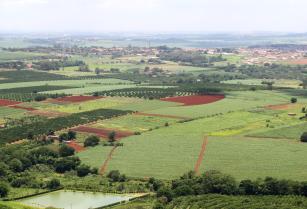
Photo: FIORINI, Flavia B.
Campinas' Metropolitan region has a wide selection of information and data that might be used to promote a better understanding of the agricultural and stockbreeding sector to society. This information is rarely accessed by elementary students due to the lack of personalized didactic material, elaborated by teachers, with the depth required in class. The GeoAtlas project aims to supply this gap with the elaboration of the School Atlas of Campinas' Metropolitan Region. It focuses on the main regional agricultural products: animal production, and coffee, sugarcane, flower, fruit and vegetable production The project has an interdisciplinary approach which involves the county's researchers and teachers, who work together to develop didactic material based in geo-technological tools. The intent is to contribute to the adoption of new education practices and to deepen the understanding of themes regarding agricultural importance on the formation of landscape and regional territories. The active participation of Campinas' county teachers will help to define approach strategies in the process of gathering content to the didactic material, according to the guidelines of National Curricular Parameters. The project's goal is to act in the systematization and production of data and information, and in the transfer of knowledge regarding agricultural activities and their relation with the environment, the economy, the society and RMC's space production. The proposal is to include regular content anchored to Atlas' main themes in elementary school's regular curriculum: regional agriculture and stockbreeding. It is of utmost importance to citizens' formation to stimulate the observation and analysis of themes in local scale, once world relations materialize and may be comprehended and transformed mainly in their nearby neighborhoods. The approximation between local research centers and educators contribute to the elevation of the researches' results to classrooms, and provide a way to transform school into an environment capable of producing knowledge, and not only to reproduce it. The project's main goal will be to publish the School Atlas of Campinas' Metropolitan Region. A series of products will also be derived from this experience, such as: webpage to store data and information obtained throughout the project and host the didactic material produced; training courses for the county's teachers on regional themes linked to agriculture, stockbreeding and geo-technologies; workshops run in partnership with teachers in order to discuss curriculum components; geo-reference-themed database; and RMC's image database, focusing on regional agricultural and stockbreeding information.
For more information access http://www.cnpm.embrapa.br/projetos/geoatlas
For more information access http://www.cnpm.embrapa.br/projetos/geoatlas
Ecosystem: Semi-mixed and seasonal forests
Status: Completed Start date: Wed Apr 01 00:00:00 GMT-03:00 2009 Conclusion date: Mon Dec 31 00:00:00 GMT-03:00 2012
Head Unit: Embrapa Territorial
Project leader: Cristina Criscuolo
Contact: cristina.criscuolo@embrapa.br